
Kibungo topographic map
Interactive map
Click on the map to display elevation.
About this map
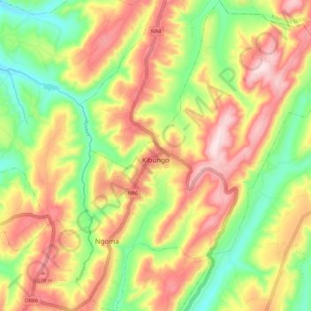
Name: Kibungo topographic map, elevation, terrain.
Location: Kibungo, Ngoma District, Eastern Province, Rwanda (-2.18900 30.52904 -2.08863 30.61364)
Average elevation: 1,541 m
Minimum elevation: 1,355 m
Maximum elevation: 1,733 m
Other topographic maps
Click on a map to view its topography, its elevation and its terrain.