
Make a donation
Gear up for your next adventure:
As an Amazon Associate, this site earns from qualifying purchases at no extra cost to you.
Calumet Township topographic map
Click on the map to display elevation.
Make a donation
Gear up for your next adventure:
As an Amazon Associate, this site earns from qualifying purchases at no extra cost to you.
About this map
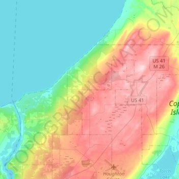
Name: Calumet Township topographic map, elevation, terrain.
Location: Calumet Township, Houghton County, Michigan, United States (47.19931 -88.55260 47.28610 -88.29899)
Average elevation: 261 m
Minimum elevation: 177 m
Maximum elevation: 399 m
Make a donation
Gear up for your next adventure:
As an Amazon Associate, this site earns from qualifying purchases at no extra cost to you.
Other topographic maps
Click on a map to view its topography, its elevation and its terrain.
Centennial Heights
United States > Michigan > Houghton County > Calumet Township
Average elevation: 364 m
Limestone Mountain
United States > Michigan > Houghton County > Laird Township
Average elevation: 245 m
Make a donation
Gear up for your next adventure:
As an Amazon Associate, this site earns from qualifying purchases at no extra cost to you.