
Make a donation
Gear up for your next adventure:
As an Amazon Associate, this site earns from qualifying purchases at no extra cost to you.
Panchthar topographic map
Click on the map to display elevation.
Make a donation
Gear up for your next adventure:
As an Amazon Associate, this site earns from qualifying purchases at no extra cost to you.
About this map
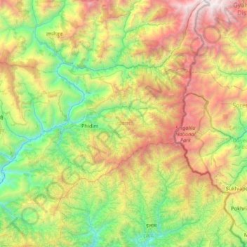
Name: Panchthar topographic map, elevation, terrain.
Location: Panchthar, Koshi Province, 57408, Nepal (26.86002 87.49243 27.43848 88.08009)
Average elevation: 1,805 m
Minimum elevation: 347 m
Maximum elevation: 4,619 m
Make a donation
Gear up for your next adventure:
As an Amazon Associate, this site earns from qualifying purchases at no extra cost to you.
Other topographic maps
Click on a map to view its topography, its elevation and its terrain.
Kala Patthar
Nepal > Koshi Province > Solukhumbu
The views of Everest, Nuptse and Changtse are spectacular from Kala Patthar and there are glimpses of the northern flank and summit of Lhotse. The world's highest webcam, Mount Everest webcam, was located here. Kala Patthar is considered the highest altitude most will reach without a climbing permit, which…
Average elevation: 5,434 m
Mount Everest
Nepal > Koshi Province > Solukhumbu
Mount Everest (Nepali: सगरमाथा, romanized: Sagarmāthā; Tibetan: Chomolungma ཇོ་མོ་གླང་མ; Chinese: 珠穆朗玛峰; pinyin: Zhūmùlǎngmǎ Fēng) is Earth's highest mountain above sea level, located in the Mahalangur Himal sub-range of the Himalayas. The China–Nepal…
Average elevation: 7,850 m
Make a donation
Gear up for your next adventure:
As an Amazon Associate, this site earns from qualifying purchases at no extra cost to you.
Make a donation
Gear up for your next adventure:
As an Amazon Associate, this site earns from qualifying purchases at no extra cost to you.
Ilam
Nepal > Koshi Province > Ilam
The word ‘Ilam’ comprises two words-‘I’ and ‘Lam’. In Limbu language, the word ‘I’ means ‘winding’ and ‘lam’ denotes the way. The topography of this Ilam aptly depicts several winding paths crisscrossing.
Average elevation: 919 m
Make a donation
Gear up for your next adventure:
As an Amazon Associate, this site earns from qualifying purchases at no extra cost to you.
Hillary Step
Nepal > Koshi Province > Solukhumbu
The step was named after Sir Edmund Hillary, who was the first known person, along with Tenzing Norgay, to scale it on the way to the summit during the 1953 British Mount Everest Expedition. Hillary and Tenzing first climbed the Hillary Step on 29 May 1953 by climbing the crack between the snow and the rock.…
Average elevation: 7,824 m
Make a donation
Gear up for your next adventure:
As an Amazon Associate, this site earns from qualifying purchases at no extra cost to you.
Make a donation
Gear up for your next adventure:
As an Amazon Associate, this site earns from qualifying purchases at no extra cost to you.