
Make a donation
Gear up for your next adventure:
As an Amazon Associate, this site earns from qualifying purchases at no extra cost to you.
Kisumu topographic map
Click on the map to display elevation.
Make a donation
Gear up for your next adventure:
As an Amazon Associate, this site earns from qualifying purchases at no extra cost to you.
Kisumu
Its elevation is 1,131 m (3,711 ft) above sea level. Kisumu is about 320 km (200 mi) northwest of Nairobi and is located on the shores of Lake Victoria. It lies at the northeastern edge of the Winam Gulf, a long, shallow arm that protrudes from the main body of Lake Victoria. Kisumu is 24 km (15 mi) south of the equator and has, due to its elevation, moderate temperatures.
Make a donation
Gear up for your next adventure:
As an Amazon Associate, this site earns from qualifying purchases at no extra cost to you.
About this map
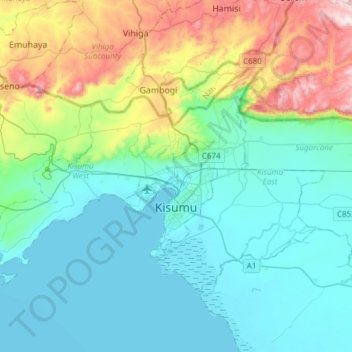
Name: Kisumu topographic map, elevation, terrain.
Location: Kisumu, City of Kisumu, Kisumu County, Nyanza, Kenya (-0.17522 34.57992 0.02263 34.88231)
Average elevation: 1,310 m
Minimum elevation: 1,131 m
Maximum elevation: 1,930 m
Make a donation
Gear up for your next adventure:
As an Amazon Associate, this site earns from qualifying purchases at no extra cost to you.
Other topographic maps
Click on a map to view its topography, its elevation and its terrain.
Kisumu
Kisumu literally means a place of barter trade "sumo". The city has "Friendship" status with Cheltenham, United Kingdom and "sister city" status with Roanoke, Virginia and Boulder, Colorado, United States. It sits at an elevation of 1,131 m (3,711 ft). Kisumu is 200 miles north west of Nairobi and its located…
Average elevation: 1,219 m
Make a donation
Gear up for your next adventure:
As an Amazon Associate, this site earns from qualifying purchases at no extra cost to you.
Make a donation
Gear up for your next adventure:
As an Amazon Associate, this site earns from qualifying purchases at no extra cost to you.
Make a donation
Gear up for your next adventure:
As an Amazon Associate, this site earns from qualifying purchases at no extra cost to you.
Make a donation
Gear up for your next adventure:
As an Amazon Associate, this site earns from qualifying purchases at no extra cost to you.