
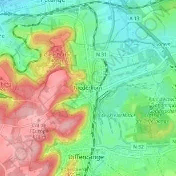
Niederkorn topographic map
Interactive map
Click on the map to display elevation.
About this map
Name: Niederkorn topographic map, elevation, terrain.
Average elevation: 329 m
Minimum elevation: 270 m
Maximum elevation: 422 m
Other topographic maps
Click on a map to view its topography, its elevation and its terrain.
Rattem
Luxembourg > Canton Esch-sur-Alzette > Differdange
Rattem, Differdange, Canton Esch-sur-Alzette, 4658, Luxembourg
Average elevation: 345 m
Oberkorn
Luxembourg > Canton Esch-sur-Alzette > Differdange > Oberkorn
Oberkorn, Differdange, Canton Esch-sur-Alzette, 4649, Luxembourg
Average elevation: 358 m