
Olbernhau topographic map
Click on the map to display elevation.
About this map
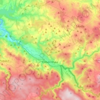
Name: Olbernhau topographic map, elevation, terrain.
Location: Olbernhau, Erzgebirgskreis, Saxony, 09526, Germany (50.59679 13.23731 50.75304 13.44796)
Average elevation: 612 m
Minimum elevation: 392 m
Maximum elevation: 842 m
Other topographic maps
Click on a map to view its topography, its elevation and its terrain.
Markersbach
Germany > Saxony > Erzgebirgskreis
In 1889, Markersbach was connected to the railway line from Schwarzenberg to Annaberg, which was closed to passenger transport on 27 September 1997. The station lay in Mittweida’s municipal area and the platform signs read Mittweida-Markersbach. To overcome the great elevation differential, the railway's…
Average elevation: 600 m