
Fürth topographic map
Interactive map
Click on the map to display elevation.
About this map
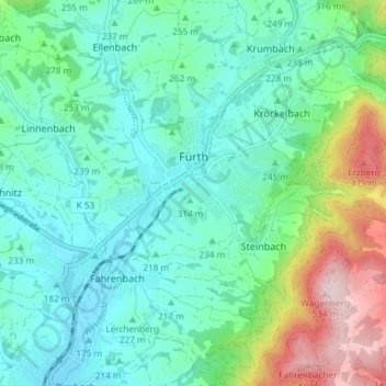
Name: Fürth topographic map, elevation, terrain.
Location: Fürth, Kreis Bergstraße, Hesse, 64658, Germany (49.62903 8.75274 49.66692 8.82672)
Average elevation: 266 m
Minimum elevation: 175 m
Maximum elevation: 542 m
Other topographic maps
Click on a map to view its topography, its elevation and its terrain.
Wald-Michelbach
Germany > Hesse > Kreis Bergstraße > Wald-Michelbach > Wald-Michelbach
Average elevation: 396 m