
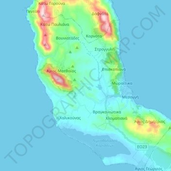
Municipal Unit of Meliteieis topographic map
Interactive map
Click on the map to display elevation.
About this map
Name: Municipal Unit of Meliteieis topographic map, elevation, terrain.
Average elevation: 46 m
Minimum elevation: -4 m
Maximum elevation: 452 m
Other topographic maps
Click on a map to view its topography, its elevation and its terrain.
Agios Spiridon
Greece > Peloponnese, Western Greece and the Ionian > Corfu Regional Unit
Average elevation: 21 m
Agios Markos
Greece > Peloponnese, Western Greece and the Ionian > Corfu Regional Unit
Average elevation: 218 m
Analipsi
Greece > Peloponnese, Western Greece and the Ionian > Corfu Regional Unit > Agios Markos
Average elevation: 141 m
Vatos
Greece > Peloponnese, Western Greece and the Ionian > Corfu Regional Unit
Average elevation: 65 m
Ano Korakiana
Greece > Peloponnese, Western Greece and the Ionian > Corfu Regional Unit
Average elevation: 244 m
Kassiopi
Greece > Peloponnese, Western Greece and the Ionian > Corfu Regional Unit > Kassopaia Municipal Unit
Average elevation: 59 m
Lefkimmi
Greece > Peloponnese, Western Greece and the Ionian > Corfu Regional Unit > Municipal Unit of Lefkimmi
Average elevation: 17 m
Moraitika
Greece > Peloponnese, Western Greece and the Ionian > Corfu Regional Unit > Municipal Unit of Meliteieis
Average elevation: 24 m
Arilas
Greece > Peloponnese, Western Greece and the Ionian > Corfu Regional Unit
Average elevation: 34 m
Marmaro
Greece > Peloponnese, Western Greece and the Ionian > Corfu Regional Unit
Average elevation: 120 m
Peroulades
Greece > Peloponnese, Western Greece and the Ionian > Corfu Regional Unit
Average elevation: 27 m
Λάκωνες
Greece > Peloponnese, Western Greece and the Ionian > Corfu Regional Unit
Average elevation: 206 m
Kommeno
Greece > Peloponnese, Western Greece and the Ionian > Corfu Regional Unit > Gouvia
Average elevation: 9 m
Benitses
Greece > Peloponnese, Western Greece and the Ionian > Corfu Regional Unit
Average elevation: 88 m
Gouvia
Greece > Peloponnese, Western Greece and the Ionian > Corfu Regional Unit
Average elevation: 29 m
Σταυρός
Greece > Peloponnese, Western Greece and the Ionian > Corfu Regional Unit > Othonoi Municipal Unit
Average elevation: 62 m
Komianata
Greece > Peloponnese, Western Greece and the Ionian > Corfu Regional Unit > Dafnata
Average elevation: 124 m
Afionas
Greece > Peloponnese, Western Greece and the Ionian > Corfu Regional Unit > Afionas
Average elevation: 26 m
Nissaki
Greece > Peloponnese, Western Greece and the Ionian > Corfu Regional Unit > Kassopaia Municipal Unit
Average elevation: 154 m