
Arilas topographic map
Interactive map
Click on the map to display elevation.
About this map
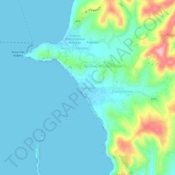
Name: Arilas topographic map, elevation, terrain.
Average elevation: 34 m
Minimum elevation: -1 m
Maximum elevation: 171 m
Other topographic maps
Click on a map to view its topography, its elevation and its terrain.
Τραχειά
Greece > Peloponnese, Western Greece and the Ionian > Corfu Regional Unit > Mathraki Municipal Unit
Average elevation: 2 m
Λάκωνες
Greece > Peloponnese, Western Greece and the Ionian > Corfu Regional Unit
Average elevation: 206 m
Municipal Unit of Meliteieis
Greece > Peloponnese, Western Greece and the Ionian > Corfu Regional Unit
Average elevation: 46 m
Ερεικούσσα
Greece > Peloponnese, Western Greece and the Ionian > Corfu Regional Unit > Ereikoussa Municipal Unit
Average elevation: 14 m