Geolocate

Jiaojiang District topographic map

Interactive map

Click on the map to display elevation.

About this map

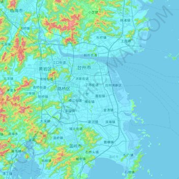
Name: Jiaojiang District topographic map, elevation, terrain.

Location: Jiaojiang District, Taizhou, Zhejiang, 318000, China (28.37459 121.34078 28.78058 122.07008)

Average elevation: 57 m

Minimum elevation: -3 m

Maximum elevation: 743 m

Other topographic maps

Click on a map to view its topography, its elevation and its terrain.

Zhoushan

China > Zhejiang

Average elevation: 10 m

Dashi Village

China > Zhejiang > Hangzhou City

Average elevation: 375 m

Linping District

China > Zhejiang

Average elevation: 10 m

Yuecheng District

China > Zhejiang

Average elevation: 45 m

Yuyue

China > Zhejiang > Huzhou

Average elevation: 5 m

Anji County

China > Zhejiang

Anji County is located within the Yangtze Delta, where the Yangtze meets the East China Sea. The Tianmu Mountains run through southwest portion of the county, with the county's highest point, Longwang Mountain [zh], reaching 1,587.4 metres (5,208 ft) in elevation. Xitiao River, the county's longest river,…

Average elevation: 207 m

Binjiang District

China > Zhejiang

Average elevation: 14 m

Fenghua District

China > Zhejiang

Average elevation: 208 m

Shangyu District

China > Zhejiang

Fuzhi mountain located in the border area of Shangyu, Shengzhou and Yuyao city. The elevation of Fuzhi mountain is 861.3 meters, cloud and mist around the mountain almost whole year, and a stone river rolling with the slope. The existence of stone river duo to the quaternary glacier movements.

Average elevation: 89 m

Hengdian

China > Zhejiang > Jinhua

Average elevation: 177 m

Taizhou

China > Zhejiang

Average elevation: 141 m

Quzhou

China > Zhejiang

Average elevation: 386 m

Yunhe

China > Zhejiang

Average elevation: 600 m

玉皇山

China > Zhejiang > Hangzhou City

Average elevation: 53 m

涧峰村

China > Zhejiang > Quzhou

Average elevation: 84 m

Wenling

China > Zhejiang

Average elevation: 44 m

Haining

China > Zhejiang

Average elevation: 5 m

Tonglu County

China > Zhejiang

Average elevation: 255 m

Guan Shan

China > Zhejiang > Daishan County

Average elevation: 16 m

Shangcheng District

China > Zhejiang

Average elevation: 20 m

Longwan District

China > Zhejiang

Average elevation: 30 m

杜城里

China > Zhejiang > Yuhang District > Liangzhu

Average elevation: 11 m

Longquan

China > Zhejiang

Average elevation: 731 m

Dongyang

China > Zhejiang

Dongbai Mountain (东白山)'s highest peak, Taibai Peak) is the main peak of the Kuaiji Mountains, with an altitude of 1194.6 meters. The main peak is located in Hulu Town, Dongyang City, Zhejiang Province. Since ancient times, it has been the head of the famous mountains in central Zhejiang, the "roof" of…

Average elevation: 262 m

Jinyun County

China > Zhejiang

Average elevation: 396 m

Jiangshan City

China > Zhejiang

Average elevation: 419 m

Jiande

China > Zhejiang

Average elevation: 262 m

Xinan

China > Zhejiang > Kecheng District

Average elevation: 67 m

Chengzhong

China > Zhejiang > Wucheng District

Average elevation: 48 m

Wuxing District

China > Zhejiang

Average elevation: 17 m

Ningbo

China > Zhejiang

Average elevation: 92 m

Wencheng County

China > Zhejiang

Average elevation: 470 m

Shangxi

China > Zhejiang

Average elevation: 104 m

Jindong District

China > Zhejiang

Average elevation: 163 m

Xinjie

China > Zhejiang > Xiaoshan District

Average elevation: 8 m

Qiantang District

China > Zhejiang

Average elevation: 7 m

Hangzhou City

China > Zhejiang

Average elevation: 186 m

Yang Mountain

China > Zhejiang > Ningbo

Average elevation: 200 m

Liucheng

China > Zhejiang > Wuyi County

Average elevation: 494 m

Pingyao

China > Zhejiang > Yuhang District > Pingyao

Average elevation: 48 m

Tiantai County

China > Zhejiang > Tiantai County

Average elevation: 348 m

Xihu District

China > Zhejiang

About the formation of West Lake, there are few records in ancient documents. The "West Lake Sight-Seeing Record" (西湖游覽志) says, "West Lake is surrounded by mountains on three sides. Streams wander down the hills into the pond. There're hundreds of springs underneath. Accumulated water forms the…

Average elevation: 19 m

Kaihua County

China > Zhejiang > Kaihua County

Average elevation: 378 m

Beijie

China > Zhejiang > Beijie

Average elevation: 403 m

Chian

China > Zhejiang

Average elevation: 130 m

贴沙河

China > Zhejiang > Shangcheng District > Chaoming

Average elevation: 14 m

Qingbo

China > Zhejiang > Shangcheng District > Qingbo > Qingbo

Average elevation: 21 m

鉴湖

China > Zhejiang > Keqiao District

Average elevation: 22 m

Wenzhou

China > Zhejiang

Most of Wenzhou's landscape is mountainous, with many mountain tops reaching altitudes in excess of 1,000 m (3,300 ft), for example in the Yandang Mountains, a coastal mountain range dominating the eastern part of prefecture. Another dominating landscape element is the Ou River, the largest river in Wenzhou…

Average elevation: 217 m

Yiwu

China > Zhejiang

Average elevation: 202 m