
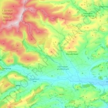
Llanrhaeadr-ym-Mochnant topographic map
Interactive map
Click on the map to display elevation.
About this map
Name: Llanrhaeadr-ym-Mochnant topographic map, elevation, terrain.
Location: Llanrhaeadr-ym-Mochnant, Powys, Wales, United Kingdom (52.78832 -3.44938 52.89341 -3.24378)
Average elevation: 359 m
Minimum elevation: 103 m
Maximum elevation: 822 m
Powys trails, hiking, mountain biking, running and outdoor activities
Other topographic maps
Click on a map to view its topography, its elevation and its terrain.
Knighton
United Kingdom > Wales > Powys
The town became a borough in 1203, with a charter permitting a weekly market and annual fair. The presence of two castles within a comparatively small town suggests that one (the earlier motte and bailey sited atop the town) went out of use before the establishment of the second (the motte with no bailey at…
Average elevation: 295 m
Grwyne Fawr Reservoir
United Kingdom > Wales > Powys
By the end of the 19th-century there were serious water shortages in the western parts of the historic county of Monmouthshire. The area had seen a massive population increase as a result of the steel and coal industries but the supply of water to the area was complicated due to its high altitude. A site for a…
Average elevation: 619 m
River Severn
United Kingdom > Wales > Powys > Welshpool
The River Severn (Welsh: Afon Hafren, pronounced [ˈavɔn ˈhavrɛn]), at 220 miles (354 km) long, is the longest river in Great Britain. It is also the river with the most voluminous flow of water by far in all of England and Wales, with an average flow rate of 107 m3/s (3,800 cu ft/s) at Apperley,…
Average elevation: 92 m