Geolocate

Norg topographic map

Click on the map to display elevation.

About this map

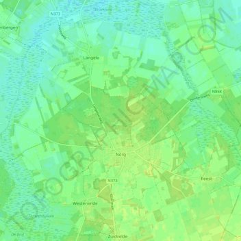
Name: Norg topographic map, elevation, terrain.

Location: Norg, Noordenveld, Drenthe, Netherlands (53.05351 6.40694 53.09670 6.51284)

Average elevation: 8 m

Minimum elevation: 1 m

Maximum elevation: 14 m

Other topographic maps

Click on a map to view its topography, its elevation and its terrain.

Lhee

Netherlands > Drenthe

Average elevation: 11 m

Hondsrug

Netherlands > Drenthe > Exloo

Average elevation: 19 m

Zuidbarge

Netherlands > Drenthe > Emmen

Average elevation: 20 m

Gear up for your next adventure:

🍱Food Containers - Reusable containers for outdoor meals
🧗Locking Carabiners - Secure gear to your pack or for light technical use
🩹Hiking First Aid Kits - Compact medical kits tailored for trail injuries and emergencies
🔦Keychain LED Torches - Emergency backup light for finding gear in your pack
🌄Outdoor Binoculars - Compact binoculars for landscape observation

As an Amazon Associate, this site earns from qualifying purchases at no extra cost to you.