
Thank you for supporting this site ❤️
Make a donation
Make a donation
Gear up for your next adventure:
As an Amazon Associate, this site earns from qualifying purchases at no extra cost to you.
Kimotsuki topographic map
Click on the map to display elevation.
Thank you for supporting this site ❤️
Make a donation
Make a donation
Gear up for your next adventure:
As an Amazon Associate, this site earns from qualifying purchases at no extra cost to you.
About this map
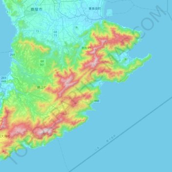
Name: Kimotsuki topographic map, elevation, terrain.
Location: Kimotsuki, Kimotsuki County, Kagoshima Prefecture, Japan (31.04239 130.88225 31.39641 131.26686)
Average elevation: 134 m
Minimum elevation: -1 m
Maximum elevation: 935 m
Thank you for supporting this site ❤️
Make a donation
Make a donation
Gear up for your next adventure:
As an Amazon Associate, this site earns from qualifying purchases at no extra cost to you.