Geolocate

Ica topographic map

Click on the map to display elevation.

About this map
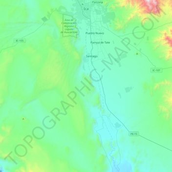
Name: Ica topographic map, elevation, terrain.

Location: Ica, Province of Ica, Ica, Peru (-14.49006 -76.07233 -14.04170 -75.71727)

Average elevation: 523 m

Minimum elevation: 264 m

Maximum elevation: 1,905 m

Other topographic maps

Click on a map to view its topography, its elevation and its terrain.
Tambilla

Peru > Ica > Chavín

Average elevation: 2,213 m

La Franja

Peru > Ica > Santiago > La Franja

Average elevation: 422 m

Symbols

Peru > Ica > San Francisco > entrada al ingenio

Average elevation: 555 m

San Miguel de la Pascana

Peru > Ica

Average elevation: 406 m

entrada al ingenio

Peru > Ica > San Miguel de la Pascana

Average elevation: 400 m

Giant

Peru > Ica > Nazca

Average elevation: 531 m

Gear up for your next adventure:

🥾Women's Waterproof Hiking Boots - High-performance trekking boots designed for all-weather comfort
🧤Thermal Touchscreen Gloves - Stay warm while operating your GPS or smartphone camera
🔪Outdoor Multi-Tools - Versatile tools for gear repairs and food prep in the wild
🎒Hiking Daypacks (20L) - Compact backpacks for day trips and technical mountain ascents
📻Hand-Crank Emergency Radios - Stay updated on weather warnings in remote areas

As an Amazon Associate, this site earns from qualifying purchases at no extra cost to you.