
Beaufort topographic map
Interactive map
Click on the map to display elevation.
About this map
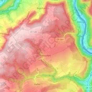
Name: Beaufort topographic map, elevation, terrain.
Location: Beaufort, Canton Echternach, Luxembourg (49.82036 6.25468 49.85988 6.33063)
Average elevation: 326 m
Minimum elevation: 170 m
Maximum elevation: 414 m
Other topographic maps
Click on a map to view its topography, its elevation and its terrain.
Mullerthal
Luxembourg > Canton Echternach > Waldbillig
Mullerthal, Waldbillig, Canton Echternach, 6245, Luxembourg
Average elevation: 313 m
Echternach
Luxembourg > Canton Echternach
Echternach, Canton Echternach, Luxembourg
Average elevation: 284 m