Geolocate

Peruva topographic map

Click on the map to display elevation.

About this map

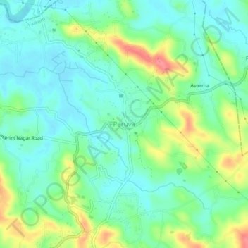
Name: Peruva topographic map, elevation, terrain.

Location: Peruva, Vaikom, Kottayam District, Kerala, 686610, India (9.80768 76.48113 9.84768 76.52113)

Average elevation: 25 m

Minimum elevation: 0 m

Maximum elevation: 79 m

Other topographic maps

Click on a map to view its topography, its elevation and its terrain.

Muvatupuzha

India > Kerala > Vaikom > Velloor

Average elevation: 14 m

Vembanadu

India > Kerala > Vaikom > Kulangara Colony

Average elevation: 2 m

Gear up for your next adventure:

🗺️Scratch-off Peak Maps - Track your progress climbing Munros or Wainwrights
🦟Anti-Midge & Tick Repellent - Vital for hiking in the Scottish Highlands during summer
🔭Compact Hiking Binoculars - Lightweight optics for scouting terrain and spotting wildlife
🌄Compact Monoculars - Lightweight optics for hiking
🧥Waterproof Hiking Jackets - Rain protection for walking in all weather conditions

As an Amazon Associate, this site earns from qualifying purchases at no extra cost to you.