
Kurmuk topographic map
Interactive map
Click on the map to display elevation.
About this map
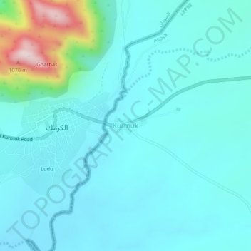
Name: Kurmuk topographic map, elevation, terrain.
Location: Kurmuk, Asosa, Benishangul-Gumuz Region, Ethiopia (10.53688 34.27607 10.57688 34.31607)
Average elevation: 698 m
Minimum elevation: 630 m
Maximum elevation: 1,087 m
Other topographic maps
Click on a map to view its topography, its elevation and its terrain.
Grand Ethiopian Renaissance Dam
Ethiopia > Benishangul-Gumuz Region
Supporting the main dam and reservoir will be a curved and 4.9 km (3 mi) long and 50 m (164 ft) high rock-fill saddle dam. The ground level of the saddle dam is at an elevation of about 600 m (2,000 ft) above sea level. The surface of the saddle dam has a bituminous finish, to keep the interior of the dam dry.…
Average elevation: 555 m