
Abruzzo topographic map
Interactive map
Click on the map to display elevation.
About this map
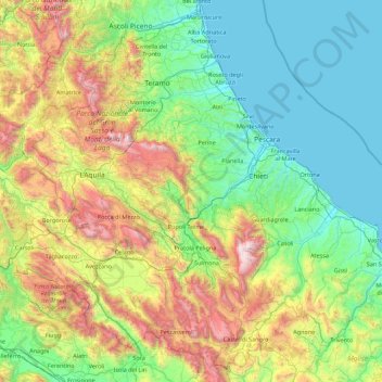
Name: Abruzzo topographic map, elevation, terrain.
Location: Abruzzo, Italy (41.68204 13.01897 42.89508 14.78389)
Average elevation: 658 m
Minimum elevation: -1 m
Maximum elevation: 2,775 m
In Abruzzo there are two climatic zones. The coastal strip and sub-Apennine hills have a climate markedly different from that of the mountainous interior. Coastal areas have a Mediterranean climate with hot dry summers and mild winters. Inland hilly areas have a sublittoral climate with temperatures decreasing progressively with increasing altitude. Precipitation is also strongly affected by the presence of the Apennines mountain range. Rainfall is abundant on slopes oriented to the west, and lower in east and east-facing slopes. The Adriatic coast is shielded from rainfall by the barrier effect created by the Apennines. The minimum annual rainfall is found in some inland valleys, sheltered by mountain ranges, such as Peligna or Tirino (Ofena, Capestrano), where as little as 500 millimetres (19.7 inches) were recorded. Rainfall along the coast almost always never falls below 600 millimetres (23.6 inches). Teramo has relatively less rainfall (about 800 millimetres (31.5 inches)) than Chieti, while Ortona, Vasto, and Costa dei Trabocchi have comparatively less rainfall. The highest rainfall occurs in upland areas on the border with Lazio; they are especially vulnerable to Atlantic disturbances. Around 1,500 to 2,000 millimetres (59 to 79 inches) of precipitation is typical.
Other topographic maps
Click on a map to view its topography, its elevation and its terrain.
Trieste
Italy > Friuli-Venezia Giulia > Trieste
Trieste, Friuli-Venezia Giulia, 34121-34151, Italy
Average elevation: 184 m
Campiglia Cervo
Campiglia Cervo, Biella, Piedmont, 13812, Italy
Average elevation: 1,358 m
Bolzano - Bozen
Italy > Trentino-Alto Adige/Südtirol > South Tyrol
Bolzano - Bozen, South Tyrol, Trentino-Alto Adige/Südtirol, 39100, Italy
Average elevation: 716 m
Novellara
Italy > Emilia-Romagna > Reggio nell'Emilia
Novellara, Bassa Reggiana, Reggio nell'Emilia, Emilia-Romagna, 42017, Italy
Average elevation: 23 m
Pirastreri
Italy > Sardinia > Nuoro > Thiniscole/Siniscola
Pirastreri, Thiniscole/Siniscola, Nuoro, Sardinia, 08029, Italy
Average elevation: 59 m
Borgomezzavalle
Italy > Piedmont > Verbano-Cusio-Ossola
Borgomezzavalle, Verbano-Cusio-Ossola, Piedmont, 28846, Italy
Average elevation: 1,082 m
Pratola Peligna
Pratola Peligna, L'Aquila, Abruzzo, 67035, Italy
Average elevation: 439 m
Sant'Elia a Pianisi
Italy > Molise > Campobasso
Sant'Elia a Pianisi, Campobasso, Molise, Italy
Average elevation: 575 m
Pozzo Fornovalasco
Italy > Tuscany > Lucca > Molazzana
Pozzo Fornovalasco, Sentiero cima pania secca, Molazzana, Unione Comuni Garfagnana, Lucca, Tuscany, Italy
Average elevation: 1,169 m
Bunnànnaru/Bonnanaro
Bunnànnaru/Bonnanaro, Sassari, Sardinia, 07043, Italy
Average elevation: 438 m
Madama
Italy > Vibo Valentia > Zambrone
Madama, Zambrone, Vibo Valentia, 89868, Italy
Average elevation: 102 m
Campagnano di Roma
Italy > Lazio > Roma Capitale
Campagnano di Roma, Roma Capitale, Lazio, 00063, Italy
Average elevation: 253 m
Serro Calderaro
Italy > Sicily > Catania > Giumarra
Serro Calderaro, Giumarra, Castel di Iudica, Catania, Sicily, 95040, Italy
Average elevation: 317 m
San Giuseppe
San Giuseppe, Alto Sermenza, Vercelli, Piedmont, 13029, Italy
Average elevation: 1,620 m
Castiglion Fiorentino
Castiglion Fiorentino, Arezzo, Tuscany, 52043, Italy
Average elevation: 374 m
Cervignano d'Adda
Cervignano d'Adda, Lodi, Lombardy, Italy
Average elevation: 89 m
Colle di Val d'Elsa
Colle di Val d'Elsa, Siena, Tuscany, 53034, Italy
Average elevation: 250 m
Pointe Helbronner / Punta Helbronner
Italy > Aosta Valley > Courmayeur
Pointe Helbronner / Punta Helbronner, Courmayeur, Aosta Valley, Italy
Average elevation: 3,072 m
Ovaro
Italy > Friuli – Venezia Giulia > Udine
Ovaro, Udine, Friuli – Venezia Giulia, 33025, Italy
Average elevation: 1,066 m