
Make a donation
Gear up for your next adventure:
As an Amazon Associate, this site earns from qualifying purchases at no extra cost to you.
Llantrisant topographic map
Click on the map to display elevation.
Make a donation
Gear up for your next adventure:
As an Amazon Associate, this site earns from qualifying purchases at no extra cost to you.
Llantrisant
Llantrisant (Welsh pronunciation: [ɬanˈtrɪsant]; "Parish of the Three Saints") is a town and community in the county borough of Rhondda Cynon Taf, Wales. It lies within the historic county boundaries of Glamorgan, on the River Ely and the Afon Clun. The three saints of the town's name are Illtyd, Gwynno, and Dyfodwg. Llantrisant is a hilltop settlement, at an altitude of 174 m (571 ft) above sea level. The town is home to the Royal Mint.
Make a donation
Gear up for your next adventure:
As an Amazon Associate, this site earns from qualifying purchases at no extra cost to you.
About this map
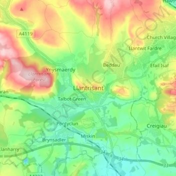
Name: Llantrisant topographic map, elevation, terrain.
Average elevation: 104 m
Minimum elevation: 16 m
Maximum elevation: 258 m
Rhondda Cynon Taf trails, hiking, mountain biking, running and outdoor activities
Make a donation
Gear up for your next adventure:
As an Amazon Associate, this site earns from qualifying purchases at no extra cost to you.
Other topographic maps
Click on a map to view its topography, its elevation and its terrain.
Make a donation
Gear up for your next adventure:
As an Amazon Associate, this site earns from qualifying purchases at no extra cost to you.
Make a donation
Gear up for your next adventure:
As an Amazon Associate, this site earns from qualifying purchases at no extra cost to you.