Geolocate

Opole topographic map

Click on the map to display elevation.

About this map

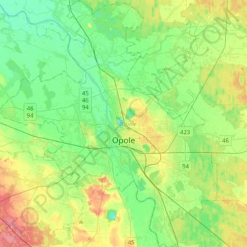
Name: Opole topographic map, elevation, terrain.

Location: Opole, Opole Voivodeship, Poland (50.58762 17.77959 50.76997 18.03269)

Average elevation: 161 m

Minimum elevation: 138 m

Maximum elevation: 206 m

Other topographic maps

Click on a map to view its topography, its elevation and its terrain.

Małujowice

Poland > Opole Voivodeship > Brzeg County

Average elevation: 152 m

Krasków

Poland > Opole Voivodeship > Kluczbork County

Average elevation: 183 m

Pokój

Poland > Opole Voivodeship > Namysłów County

Average elevation: 157 m

Rybaczówka

Poland > Opole Voivodeship > Opole County > Turawa

Average elevation: 175 m

Stare Olesno

Poland > Opole Voivodeship > Olesno County

Average elevation: 218 m

Ujazd

Poland > Opole Voivodeship > Strzelce County > Ujazd > Ujazd

Average elevation: 212 m

Gear up for your next adventure:

🧺Microfibre Travel Towels - Fast-drying and compact towels for wild swimming and camping
📕Outdoor Navigation Books - Learn traditional and modern navigation techniques
🧼Technical Clothing Wash - Special soap to clean and restore waterproof membranes
🗺️Ordnance Survey Maps - Official UK maps for walking and outdoor activities
🧺Ultralight Dry Bags - Organize and waterproof your gear inside your rucksack

As an Amazon Associate, this site earns from qualifying purchases at no extra cost to you.