
Sơn Trà District topographic map
Interactive map
Click on the map to display elevation.
About this map
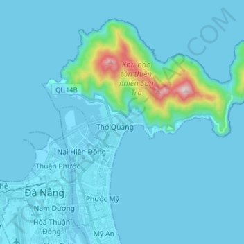
Name: Sơn Trà District topographic map, elevation, terrain.
Location: Sơn Trà District, Da Nang, Vietnam (16.05085 108.20903 16.15565 108.33912)
Average elevation: 48 m
Minimum elevation: -1 m
Maximum elevation: 668 m
Other topographic maps
Click on a map to view its topography, its elevation and its terrain.
Xã Hòa Ninh
Xã Hòa Ninh, Hòa Vang District, Đà Nẵng, Vietnam
Average elevation: 108 m
Ban Co Peak
Ban Co Peak, Đường Lê Văn Lương, Phường Thọ Quang, Sơn Trà District, Đà Nẵng, 50207, Vietnam
Average elevation: 308 m
Bán đảo Sơn Trà
Bán đảo Sơn Trà, Phường Thọ Quang, Sơn Trà District, Da Nang, Vietnam
Average elevation: 285 m
Cam Le River
Cam Le River, Cẩm Lệ District, Da Nang, 550000, Vietnam
Average elevation: 5 m