
Kahawa topographic map
Interactive map
Click on the map to display elevation.
About this map
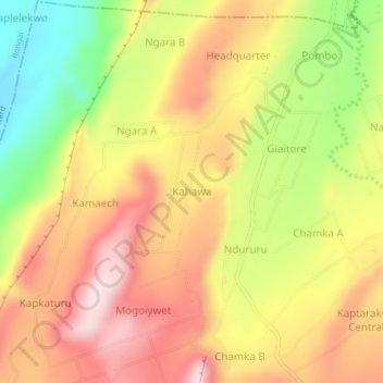
Name: Kahawa topographic map, elevation, terrain.
Location: Kahawa, Waseges ward, Subukia, Nakuru, Rift Valley, Kenya (0.06193 36.18809 0.10193 36.22809)
Average elevation: 1,844 m
Minimum elevation: 1,600 m
Maximum elevation: 2,040 m
Other topographic maps
Click on a map to view its topography, its elevation and its terrain.