
Pointe d'Archeboc topographic map
Interactive map
Click on the map to display elevation.
About this map
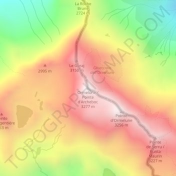
Name: Pointe d'Archeboc topographic map, elevation, terrain.
Location: Pointe d'Archeboc, Valgrisenche, Vallée d'Aoste, Italie (45.58334 6.98053 45.58344 6.98063)
Average elevation: 2,778 m
Minimum elevation: 2,149 m
Maximum elevation: 3,260 m
Other topographic maps
Click on a map to view its topography, its elevation and its terrain.
Mont Pela
Italie > Vallée d'Aoste > Valgrisenche
Mont Pela, Valgrisenche, Vallée d'Aoste, Italie
Average elevation: 2,216 m