
Mont Pela topographic map
Interactive map
Click on the map to display elevation.
About this map
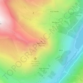
Name: Mont Pela topographic map, elevation, terrain.
Location: Mont Pela, Valgrisenche, Vallée d'Aoste, Italie (45.60439 7.03169 45.60449 7.03179)
Average elevation: 2,216 m
Minimum elevation: 1,695 m
Maximum elevation: 2,888 m
Other topographic maps
Click on a map to view its topography, its elevation and its terrain.
Pointe d'Archeboc
Italie > Vallée d'Aoste > Valgrisenche
Pointe d'Archeboc, Valgrisenche, Vallée d'Aoste, Italie
Average elevation: 2,778 m