
Jerusalem topographic map
Interactive map
Click on the map to display elevation.
Jerusalem
Jerusalem is situated on the southern spur of a plateau in the Judaean Mountains, which include the Mount of Olives (East) and Mount Scopus (North East). The elevation of the Old City is approximately 760 m (2,490 ft). The whole of Jerusalem is surrounded by valleys and dry riverbeds (wadis). The Kidron, Hinnom, and Tyropoeon Valleys intersect in an area just south of the Old City of Jerusalem. The Kidron Valley runs to the east of the Old City and separates the Mount of Olives from the city proper. Along the southern side of old Jerusalem is the Valley of Hinnom, a steep ravine associated in biblical eschatology with the concept of Gehenna or Hell. The Tyropoeon Valley commenced in the northwest near the Damascus Gate, ran south-southeasterly through the centre of the Old City down to the Pool of Siloam, and divided the lower part into two hills, the Temple Mount to the east, and the rest of the city to the west (the lower and the upper cities described by Josephus). Today, this valley is hidden by debris that has accumulated over the centuries. In biblical times, Jerusalem was surrounded by forests of almond, olive and pine trees. Over centuries of warfare and neglect, these forests were destroyed. Farmers in the Jerusalem region thus built stone terraces along the slopes to hold back the soil, a feature still very much in evidence in the Jerusalem landscape.
About this map
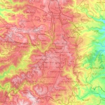
Name: Jerusalem topographic map, elevation, terrain.
Location: Jerusalem, Jerusalem Subdistrict, Jerusalem District, Israel (31.70962 35.08520 31.88267 35.26505)
Average elevation: 659 m
Minimum elevation: 251 m
Maximum elevation: 921 m
Other topographic maps
Click on a map to view its topography, its elevation and its terrain.
Haifa
Haifa is the center of liberal Arabic-speaking culture, as it was under British colonial rule. The Arabic-speaking neighborhoods, which are mixed Muslim and Christian, are in the lowlands near the sea, while Jewish neighborhoods are at higher elevation. An active Arab cultural life has developed in the 21st…
Average elevation: 100 m
Golan Heights
Israel > North District > Golan Regional Council
The plateau that Israel controls is part of a larger area of volcanic basalt fields stretching north and east that were created in the series of volcanic eruptions that began recently in geological terms, almost 4 million years ago. The rock forming the mountainous area in the northern Golan Heights,…
Average elevation: 533 m
Jerusalem
Jerusalem is situated on the southern spur of a plateau in the Judaean Mountains, which include the Mount of Olives (East) and Mount Scopus (North East). The elevation of the Old City is approximately 760 m (2,490 ft). The whole of Jerusalem is surrounded by valleys and dry riverbeds (wadis). The Kidron,…
Average elevation: 520 m
Matat
Israel > North District > Maale Yosef Regional Council
Mattat's name is equivalent in gematria to 840, its altitude in metres. The high location and mountainous region provides the town with a relatively temperate climate. Summer temperatures rarely break 30 °C and humidity is low, and summer nights are even chilly. The winters are cold and wet, with an average…
Average elevation: 755 m
Hof Dor & Ma'agan Michael Islans Nature Reserve
Israel > Haifa District > Hof HaCarmel Regional Council
Average elevation: 2 m
Mount Meron
Israel > North District > Merom HaGalil Regional Council
Mount Meron (Hebrew: הַר מֵירוֹן, Har Meron; Arabic: جبل الجرمق, Jabal al-Jarmaq) is a mountain in the Upper Galilee region of Israel. It has special significance in Jewish religious tradition and parts of it have been declared a nature reserve. At 1,204 metres (3,950 ft) above sea level,…
Average elevation: 943 m
Mitzpe Ramon
Israel > South District > Mizpe Ramon
Mitzpe Ramon (Hebrew: מִצְפֵּה רָמוֹן, Ramon Lookout; Arabic: متسبي رمون) is a local council in the Negev desert of southern Israel. It is situated on the northern ridge at an elevation of 860 meters (2,800 feet) overlooking the world's largest erosion cirque, known as the Makhtesh…
Average elevation: 778 m