
Leoben topographic map
Interactive map
Click on the map to display elevation.
About this map
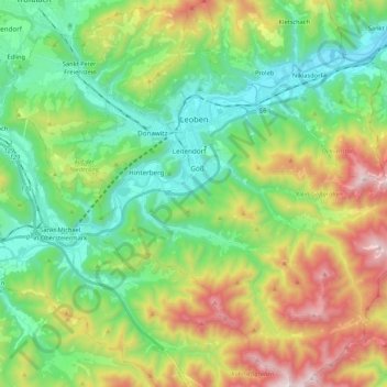
Name: Leoben topographic map, elevation, terrain.
Location: Leoben, Bezirk Leoben, Styria, Austria (47.28043 15.02718 47.42461 15.23230)
Average elevation: 871 m
Minimum elevation: 493 m
Maximum elevation: 1,639 m
Other topographic maps
Click on a map to view its topography, its elevation and its terrain.
Eisenerz
Austria > Styria > Bezirk Leoben
Eisenerz, Bezirk Leoben, Styria, 8790, Austria
Average elevation: 1,283 m
Trofaiach
Austria > Styria > Bezirk Leoben
Trofaiach, Bezirk Leoben, Styria, 8793, Austria
Average elevation: 1,066 m