
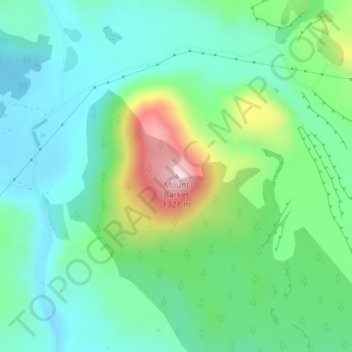
Mt Barker topographic map
Interactive map
Click on the map to display elevation.
About this map
Name: Mt Barker topographic map, elevation, terrain.
Location: Mt Barker, Selwyn District, Canterbury, New Zealand (-43.35093 171.60468 -43.35083 171.60478)
Average elevation: 617 m
Minimum elevation: 513 m
Maximum elevation: 892 m
Other topographic maps
Click on a map to view its topography, its elevation and its terrain.
Hydra Island
New Zealand > Canterbury > Selwyn District
Hydra Island, Selwyn District, Canterbury, New Zealand
Average elevation: 474 m
Hogs Back
New Zealand > Canterbury > Selwyn District
Hogs Back, Selwyn District, Canterbury, 7580, New Zealand
Average elevation: 925 m
Golgotha
New Zealand > Canterbury > Selwyn District
Golgotha, Selwyn District, Canterbury, New Zealand
Average elevation: 410 m
West Melton
New Zealand > Canterbury > Selwyn District
West Melton, Selwyn District, Canterbury, 7618, New Zealand
Average elevation: 88 m
Prebbleton
New Zealand > Canterbury > Selwyn District
Prebbleton, Selwyn District, Canterbury, 7604, New Zealand
Average elevation: 25 m
Arthur's Pass
New Zealand > Canterbury > Selwyn District
Arthur's Pass, Selwyn District, Canterbury, 7875, New Zealand
Average elevation: 1,204 m
Rolleston
New Zealand > Canterbury > Selwyn District
Rolleston, Selwyn District, Canterbury, 7614, New Zealand
Average elevation: 54 m