
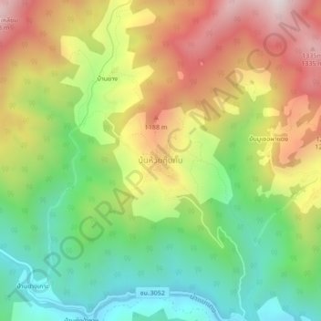
บ้นห้วยกุ๊บกั๊บ topographic map
Interactive map
Click on the map to display elevation.
About this map
Name: บ้นห้วยกุ๊บกั๊บ topographic map, elevation, terrain.
Location: บ้นห้วยกุ๊บกั๊บ, Chiang Mai, Thailand (19.22268 98.81016 19.26268 98.85016)
Average elevation: 872 m
Minimum elevation: 463 m
Maximum elevation: 1,388 m
Other topographic maps
Click on a map to view its topography, its elevation and its terrain.
หนองป่าครั่ง
หนองป่าครั่ง, ต้นเปา, อำเภอสารภี, Chiang Mai, 55520, Thailand
Average elevation: 307 m
เชียงใหม่
เชียงใหม่, ป่าแดด, อำเภอสารภี, Chiang Mai, 55520, Thailand
Average elevation: 424 m