
Crater Lake National Park topographic map
Interactive map
Click on the map to display elevation.
About this map
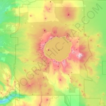
Name: Crater Lake National Park topographic map, elevation, terrain.
Average elevation: 1,726 m
Minimum elevation: 1,051 m
Maximum elevation: 2,695 m
The caldera rim ranges in elevation from 7,000 to 8,000 feet (2,100 to 2,400 m). The United States Geological Survey benchmark elevation of the lake surface is 6,178 feet (1,883 m). The national park encompasses 183,224 acres (286.3 sq mi; 741.5 km2). Crater Lake has no streams flowing into or out of it. All water that enters the lake is eventually lost from evaporation or subsurface seepage. The lake's water commonly has a striking blue hue, and the lake is refilled entirely from direct precipitation in the form of snow and rain.
Other topographic maps
Click on a map to view its topography, its elevation and its terrain.
Deepest point -592m
United States > Oregon > Klamath County
Deepest point -592m, Klamath County, Oregon, United States
Average elevation: 1,880 m
Link River
United States > Oregon > Klamath County > Klamath Falls
Link River, Klamath Falls, Klamath County, Oregon, United States
Average elevation: 1,304 m
Chiloquin
United States > Oregon > Klamath County
Chiloquin, Klamath County, Oregon, United States
Average elevation: 1,302 m
Crater Lake
United States > Oregon > Klamath County
Crater Lake, Klamath County, Oregon, United States
Average elevation: 1,971 m
Willamette Pass
United States > Oregon > Klamath County
Willamette Pass, Klamath County, Oregon, United States
Average elevation: 1,605 m
Klamath Falls
United States > Oregon > Klamath County
Klamath Falls, Klamath County, Oregon, 97601, United States
Average elevation: 1,312 m