
La Motta topographic map
Interactive map
Click on the map to display elevation.
About this map
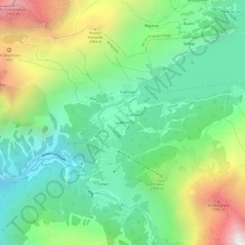
Name: La Motta topographic map, elevation, terrain.
Location: La Motta, Maloja, Bergell, Maloja, Graubünden, 7516, Schweiz (46.38371 9.68041 46.42371 9.72041)
Average elevation: 2,036 m
Minimum elevation: 1,504 m
Maximum elevation: 3,094 m
Other topographic maps
Click on a map to view its topography, its elevation and its terrain.
Orden
Schweiz > Graubünden > Maloja > Maloja
Orden, Maloja, Bergell, Maloja, Graubünden, 7516, Schweiz
Average elevation: 1,988 m
Silsersee
Schweiz > Graubünden > Maloja > Maloja
Silsersee, Maloja, Sils im Engadin, Bergell, Maloja, Graubünden, 7516, Schweiz
Average elevation: 1,948 m