
Silsersee topographic map
Interactive map
Click on the map to display elevation.
About this map
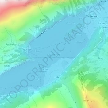
Name: Silsersee topographic map, elevation, terrain.
Average elevation: 1,948 m
Minimum elevation: 1,790 m
Maximum elevation: 2,665 m
Das nördliche Ufer – auf einer Anhöhe links hinter der ersten Stufe befindet sich Grevasalvas
Other topographic maps
Click on a map to view its topography, its elevation and its terrain.
Orden
Schweiz > Graubünden > Maloja > Maloja
Orden, Maloja, Bergell, Maloja, Graubünden, 7516, Schweiz
Average elevation: 1,988 m
La Motta
Schweiz > Graubünden > Maloja > Maloja
La Motta, Maloja, Bergell, Maloja, Graubünden, 7516, Schweiz
Average elevation: 2,036 m