
Chattogram District topographic map
Interactive map
Click on the map to display elevation.
Chattogram District
The district's topography is primarily defined by a series of low hill ranges running roughly parallel to the coast and with each other. Between these hill ranges are broad alluvial valleys with sandstone bedrock, and they are also divided by several major rivers, namely the Karnaphuli and Sangu. The most important of these ranges runs roughly from the tripoint with Feni district and Tripura in the north southeast to Chittagong city, known as the Sitakunda hills. This hill range is around 70 kilometres in length and its highest point, Chandranath, is around 350 metres in height. Along the eastern border with Khagrachhari district lies broken hill country. Another set of hills enters the district in the western part of Rangunia Upazila and ends at the Karnaphuli. South of the Karnaphuli, the hills run southeast through the eastern part of Patiya and Chandanaish upazilas to the Sangu River. South of the Sangu lies another hill range close to the coast which divides Banskhali Upazila from Satkania and Lohagara Upazilas, and continues into Cox's Bazar district. The southeastern border with Bandarban district lies along the foothills of the Hill Tracts. To the west of the hill ranges lies a coastal plain with a small width, and along the shore there are numerous beaches which have become tourist destinations.
About this map
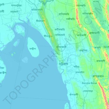
Name: Chattogram District topographic map, elevation, terrain.
Location: Chattogram District, Chattogram Division, Bangladesh (21.85623 91.25964 22.98916 92.21977)
Average elevation: 28 m
Minimum elevation: -2 m
Maximum elevation: 679 m
Other topographic maps
Click on a map to view its topography, its elevation and its terrain.
Cox's Bazar
Bangladesh > Chattogram Division
Cox's Bazar lies on a coastal plain in the southeastern corner of Bangladesh. From above, the plain appears to bulge out into the Bay of Bengal. Along the shore is an extensive area of beach and dunes. Most of the city is built on a floodplain that is lower in elevation than the dunes, making it more…
Average elevation: 8 m
Chattogram
Bangladesh > Chattogram Division > Chattogram
Chittagong lies at 22°22′0″N 91°48′0″E / 22.36667°N 91.80000°E / 22.36667; 91.80000. It straddles the coastal foothills of the Chittagong Hill Tracts in southeastern Bangladesh. The Karnaphuli River runs along the southern banks of the city, including its central business district. The…
Average elevation: 6 m
Kaptai National Park,Kaptai, Rangamati.
Bangladesh > Chattogram Division > Rajasthali Upazila
Average elevation: 85 m
Waggachara Tea Estate
Bangladesh > Chattogram Division > Rangamati Hill District
Average elevation: 64 m