
Mount Wellington topographic map
Interactive map
Click on the map to display elevation.
About this map
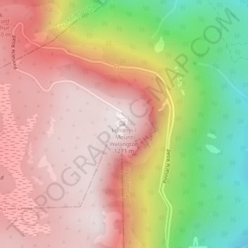
Name: Mount Wellington topographic map, elevation, terrain.
Location: Mount Wellington, City of Hobart, Tasmania, Australia (-42.89606 147.23726 -42.89596 147.23736)
Average elevation: 941 m
Minimum elevation: 443 m
Maximum elevation: 1,263 m
"... In many parts the Eucalypti grew to a great size, and composed a noble forest. In some of the dampest ravines, tree-ferns flourished in an extraordinary manner; I saw one which must have been at least twenty feet high to the base of the fronds, and was in girth exactly six feet. The fronds forming the most elegant parasols, produced a gloomy shade, like that of the first hour of the night. The summit of the mountain is broad and flat, and is composed of huge angular masses of naked greenstone. Its elevation is 3,100 feet [940 m] above the level of the sea. The day was splendidly clear, and we enjoyed a most extensive view; to the north, the country appeared a mass of wooded mountains, of about the same height with that on which we were standing, and with an equally tame outline: to the south the broken land and water, forming many intricate bays, was mapped with clearness before us. ..."
Other topographic maps
Click on a map to view its topography, its elevation and its terrain.
Goulds Country
Goulds Country, Break O'Day, Tasmania, 7216, Australia
Average elevation: 308 m
Vale of Belvoir Conservation Area
Vale of Belvoir Conservation Area, Kentish, Tasmania, Australia
Average elevation: 866 m
Lake Belton
Lake Belton, Derwent Valley, Tasmania, Australia
Average elevation: 1,056 m
Erith Island
Erith Island, Flinders Council, Tasmania, Australia
Average elevation: 23 m
Chicken Island
Chicken Island, Huon Valley, Tasmania, Australia
Average elevation: 4 m
West Hobart
West Hobart, Hobart, City of Hobart, Tasmania, 7000, Australia
Average elevation: 105 m
Mount Nelson
Mount Nelson, Hobart, City of Hobart, Tasmania, 7007, Australia
Average elevation: 198 m
Lake Pedder
Australia > Tasmania > Strathgordon
Lake Pedder, Strathgordon, Derwent Valley, Tasmania, Australia
Average elevation: 366 m
Mersey Forest
Mersey Forest, Meander Valley, Tasmania, Australia
Average elevation: 866 m
Launceston
Launceston, City of Launceston, Tasmania, Australia
Average elevation: 194 m
Port Arthur
Port Arthur, Tasman, Tasmania, 7182, Australia
Average elevation: 153 m
Highland Waters
Australia > Tasmania > London Lakes
Highland Waters, London Lakes, Central Highlands, Tasmania, Australia
Average elevation: 759 m
Bullock Hill
Bullock Hill, Grove, Huon Valley, Tasmania, Australia
Average elevation: 147 m
Grey Mares Tail
Australia > Tasmania > St Marys
Grey Mares Tail, St Marys, Break O'Day, Tasmania, Australia
Average elevation: 349 m
Anderson Island
Anderson Island, Flinders Council, Tasmania, Australia
Average elevation: 4 m
Flinders Island
Flinders Island, Tasmania, 7255, Australia
Average elevation: 20 m
Macquarie Island
Macquarie Island, Huon Valley, Tasmania, Australia
Average elevation: 20 m
Bruny Island
Australia > Tasmania > Alonnah
Bruny Island, Alonnah, Kingborough, Tasmania, Australia
Average elevation: 59 m
Deal Island
Deal Island, Flinders Council, Tasmania, Australia
Average elevation: 45 m