
Lake Belton topographic map
Interactive map
Click on the map to display elevation.
About this map
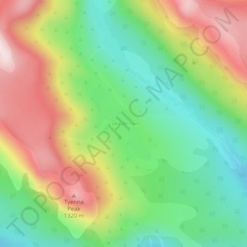
Name: Lake Belton topographic map, elevation, terrain.
Location: Lake Belton, Derwent Valley, Tasmania, Australia (-42.69816 146.55387 -42.69002 146.56283)
Average elevation: 1,056 m
Minimum elevation: 839 m
Maximum elevation: 1,350 m
Other topographic maps
Click on a map to view its topography, its elevation and its terrain.
Mount Wellington
"... In many parts the Eucalypti grew to a great size, and composed a noble forest. In some of the dampest ravines, tree-ferns flourished in an extraordinary manner; I saw one which must have been at least twenty feet high to the base of the fronds, and was in girth exactly six feet. The fronds forming the…
Average elevation: 941 m