
Robin Hood Bay topographic map
Interactive map
Click on the map to display elevation.
About this map
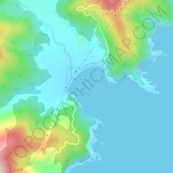
Name: Robin Hood Bay topographic map, elevation, terrain.
Location: Robin Hood Bay, Marlborough, New Zealand (-41.35809 174.07463 -41.35799 174.07473)
Average elevation: 78 m
Minimum elevation: 0 m
Maximum elevation: 371 m
Other topographic maps
Click on a map to view its topography, its elevation and its terrain.
Picton
On the land side, Picton is surrounded by hills and mountains, including Te Tara-o-Te-Marama/Mount Freeth to the west, the Robertson Range to the south and Mount McCormick to the east. The Elevation Saddle connects southwest of the town with the Tuamarina River valley and contains the main land transport…
Average elevation: 193 m