
Lunsemfwa topographic map
Interactive map
Click on the map to display elevation.
About this map
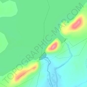
Name: Lunsemfwa topographic map, elevation, terrain.
Location: Lunsemfwa, Luano District, Central Province, Zambia (-14.23418 29.11857 -14.22730 29.11969)
Average elevation: 1,110 m
Minimum elevation: 1,074 m
Maximum elevation: 1,186 m
Other topographic maps
Click on a map to view its topography, its elevation and its terrain.
Kasanka National Park
Kasanka National Park is a park located in the Chitambo District of Zambia’s Central Province. At roughly 390 km2 (150 sq mi), Kasanka is one of Zambia’s smallest national parks. Kasanka was the first of Zambia’s national parks to be managed by a private-public partnership. The privately funded Kasanka…
Average elevation: 1,208 m