
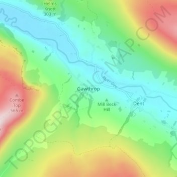
Gawthrop topographic map
Interactive map
Click on the map to display elevation.
About this map
Name: Gawthrop topographic map, elevation, terrain.
Average elevation: 272 m
Minimum elevation: 115 m
Maximum elevation: 579 m
Westmorland and Furness trails, hiking, mountain biking, running and outdoor activities
Other topographic maps
Click on a map to view its topography, its elevation and its terrain.
Wharton Tarn
United Kingdom > England > Westmorland and Furness > Hawkshead > Hawkshead Hill
Average elevation: 173 m
Newton Tarn
United Kingdom > England > Westmorland and Furness > High Newton > Low Newton
Average elevation: 102 m
Brothers Water
United Kingdom > England > Westmorland and Furness > Patterdale > Hartsop
Average elevation: 298 m
Three Dubs Tarn
United Kingdom > England > Westmorland and Furness > Bowness-on-Windermere
Average elevation: 156 m
Jack Croft's Pond
United Kingdom > England > Westmorland and Furness > Newtown
Average elevation: 217 m
Brown Cove Tarn
United Kingdom > England > Westmorland and Furness > Patterdale
Average elevation: 699 m
School Knott Tarn
United Kingdom > England > Westmorland and Furness > Windermere
Average elevation: 168 m
Knipe Tarn
United Kingdom > England > Westmorland and Furness > Winster > Mitchelland
Average elevation: 131 m
Podnet Tarn
United Kingdom > England > Westmorland and Furness > Cartmel Fell
Average elevation: 110 m
Howgill Fells
United Kingdom > England > Westmorland and Furness > Ravenstonedale
Average elevation: 303 m
River Glenderamackin
United Kingdom > England > Westmorland and Furness > Threlkeld
Average elevation: 346 m
Trout Beck
United Kingdom > England > Westmorland and Furness > Troutbeck Bridge
Average elevation: 308 m
Mallerstang Edge
United Kingdom > England > Westmorland and Furness > Mallerstang
Average elevation: 489 m
Scout Scar
United Kingdom > England > Westmorland and Furness > Brigsteer
Scout Scar, also called Underbarrow Scar, is a hill in the English Lake District, west of Kendal, Cumbria and above the village of Underbarrow. It reaches 771 feet (235 m). Scout Scar is the subject of a chapter of Wainwright's book The Outlying Fells of Lakeland, but the summit he describes is a lower summit…
Average elevation: 130 m
Roudsea Wood
United Kingdom > England > Westmorland and Furness > South Lakeland > Haverthwaite
Average elevation: 7 m
Deepdale Beck
United Kingdom > England > Westmorland and Furness > South Lakeland > Dent
Average elevation: 280 m