
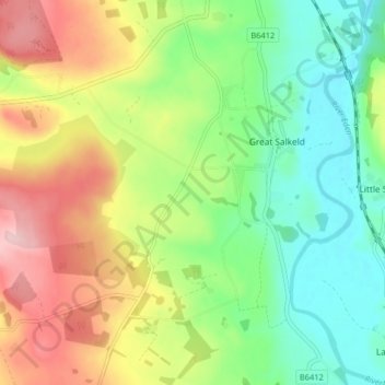
Great Salkeld topographic map
Interactive map
Click on the map to display elevation.
About this map
Name: Great Salkeld topographic map, elevation, terrain.
Average elevation: 150 m
Minimum elevation: 71 m
Maximum elevation: 267 m
Westmorland and Furness trails, hiking, mountain biking, running and outdoor activities
Other topographic maps
Click on a map to view its topography, its elevation and its terrain.
Hartsop Above How
United Kingdom > England > Westmorland and Furness > Patterdale
Average elevation: 429 m
St Sunday Crag
United Kingdom > England > Westmorland and Furness > Patterdale
Average elevation: 489 m
Birkhouse Moor
United Kingdom > England > Westmorland and Furness > Patterdale
Average elevation: 477 m
Black Fell
United Kingdom > England > Westmorland and Furness > Hawkshead
Black Fell is the high point in the hilly area bounded by Windermere, Langdale and Coniston. It occupies an area of around one mile by two, clad mainly in fell grass with many small outcrops of rock. Despite its modest altitude Alfred Wainwright accorded Black Fell a chapter in his Pictorial Guide to the…
Average elevation: 170 m
Hawkshead Hill
United Kingdom > England > Westmorland and Furness > Hawkshead
Average elevation: 157 m
Wood Broughton
United Kingdom > England > Westmorland and Furness > Field Broughton
Average elevation: 98 m
Sheffield Pike
United Kingdom > England > Westmorland and Furness > Patterdale
Average elevation: 466 m
Arnison Crag
United Kingdom > England > Westmorland and Furness > Patterdale
Although properly a northeastern ridge of Birks and having little topographical prominence, Arnison Crag was classed as a separate fell by Alfred Wainwright in his Pictorial Guide to the Lakeland Fells. That convention is followed here. In support of his decision he referred to it as ‘a low hill with a…
Average elevation: 287 m
Old Man of Coniston
United Kingdom > England > Westmorland and Furness > Coniston
The first section rising steeply from Coniston is a metalled road, maintained partly to provide access to the quarry. This leads to a car park at an altitude of 740 ft (230 m), a popular starting point for climbs. Beyond here motor vehicles are prohibited, but the track continues to its summit at 2,000 ft (610…
Average elevation: 501 m
Stony Cove Pike
United Kingdom > England > Westmorland and Furness > Patterdale
Stony Cove Pike (alternatively known as Caudale Moor /kʊərdeɪl mʊər/ or John Bell's Banner) is a fell in the Far Eastern part of the English Lake District. It stands on the other side of the Kirkstone Pass from Red Screes, and is on the end of a ridge coming down from High Street. It is separated from its…
Average elevation: 541 m
Wharton Tarn
United Kingdom > England > Westmorland and Furness > Hawkshead > Hawkshead Hill
Average elevation: 173 m
Little Langdale
United Kingdom > England > Westmorland and Furness
Little Langdale Tarn is a natural tarn within a marshy area of the valley. The area around the tarn is managed by the National Trust and has no public access. It is typical Southern Cumbrian meso-oligotrophic tarn, whilst not at a particularly high altitude itself it has a mean catchment altitude of 520 metres…
Average elevation: 183 m
Newton Tarn
United Kingdom > England > Westmorland and Furness > High Newton > Low Newton
Average elevation: 102 m
Brothers Water
United Kingdom > England > Westmorland and Furness > Patterdale > Hartsop
Average elevation: 298 m
Undermillbeck Common
United Kingdom > England > Westmorland and Furness > Crook
Average elevation: 144 m
Raven's Barrow
United Kingdom > England > Westmorland and Furness > Cartmel Fell
Average elevation: 111 m
Three Dubs Tarn
United Kingdom > England > Westmorland and Furness > Bowness-on-Windermere
Average elevation: 156 m
Jack Croft's Pond
United Kingdom > England > Westmorland and Furness > Newtown
Average elevation: 217 m
Brown Cove Tarn
United Kingdom > England > Westmorland and Furness > Patterdale
Average elevation: 699 m
School Knott Tarn
United Kingdom > England > Westmorland and Furness > Windermere
Average elevation: 168 m
Podnet Tarn
United Kingdom > England > Westmorland and Furness > Cartmel Fell
Average elevation: 110 m
Lindeth
United Kingdom > England > Westmorland and Furness > Bowness-on-Windermere
Average elevation: 111 m