
Make a donation
Gear up for your next adventure:
As an Amazon Associate, this site earns from qualifying purchases at no extra cost to you.
Harasta topographic map
Click on the map to display elevation.
Make a donation
Gear up for your next adventure:
As an Amazon Associate, this site earns from qualifying purchases at no extra cost to you.
Harasta
Harasta (Arabic: حرستا, romanized: Ḥarastā, Syriac: ܚܪܣܬܐ, romanized: Ḥarastā), also known as Harasta al-Basal or Hirista, is a town and northeastern suburb of Damascus, Rif Dimashq, Syria. Harasta has an altitude of 702 meters. It has a population of 34,184 as of 2007, making it the 43rd largest city per geographical entity in Syria.
Make a donation
Gear up for your next adventure:
As an Amazon Associate, this site earns from qualifying purchases at no extra cost to you.
About this map
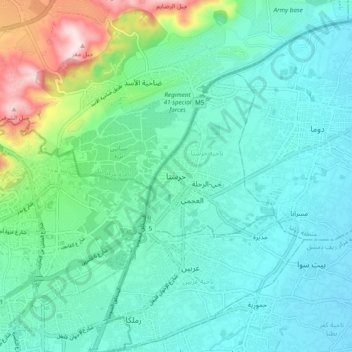
Name: Harasta topographic map, elevation, terrain.
Average elevation: 880 m
Minimum elevation: 594 m
Maximum elevation: 2,162 m
Make a donation
Gear up for your next adventure:
As an Amazon Associate, this site earns from qualifying purchases at no extra cost to you.
Other topographic maps
Click on a map to view its topography, its elevation and its terrain.
Make a donation
Gear up for your next adventure:
As an Amazon Associate, this site earns from qualifying purchases at no extra cost to you.