Geolocate

Cendá topographic map

Interactive map

Click on the map to display elevation.

About this map

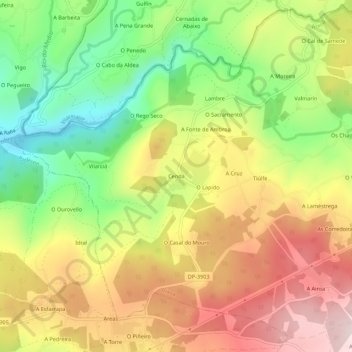
Name: Cendá topographic map, elevation, terrain.

Location: Cendá, Ambroa, Irixoa, Betanzos, A Coruña, Galicia, 15313, Spain (43.29103 -8.14284 43.33103 -8.10284)

Average elevation: 249 m

Minimum elevation: 25 m

Maximum elevation: 477 m

Other topographic maps

Click on a map to view its topography, its elevation and its terrain.

Aranga

Spain > Galicia > Betanzos

Average elevation: 486 m

Paderne

Spain > Galicia > Betanzos

Average elevation: 178 m

Vilarmaior

Spain > Galicia > Betanzos

Average elevation: 197 m

Oza-Cesuras

Spain > Galicia > Betanzos

Average elevation: 305 m

Churío

Spain > Galicia > Betanzos

Average elevation: 305 m

Irixoa

Spain > Galicia > Betanzos

Average elevation: 363 m

Vilamateo

Spain > Galicia > Betanzos

Average elevation: 233 m

Curtis

Spain > Galicia > Betanzos

Average elevation: 503 m

Oza

Spain > Galicia > Betanzos

Average elevation: 184 m

Betanzos

Spain > Galicia > Betanzos

Calunio as a toponym fits well as an evolution of "calunia" the place where calumny somehow was associated to, for example a few fishermen depicting their fishery within some augmentation. When the hamlet step up to the village status claims for a more feasible official name would stand aiming its elevation…

Average elevation: 93 m

Coirós

Spain > Galicia > Betanzos

Average elevation: 255 m