
Al Aamerah topographic map
Interactive map
Click on the map to display elevation.
About this map
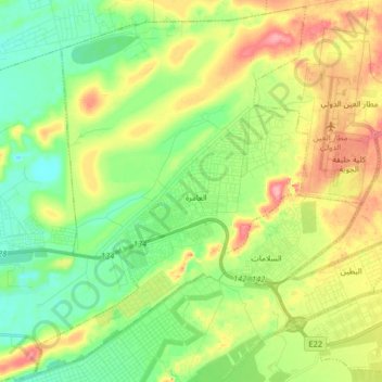
Name: Al Aamerah topographic map, elevation, terrain.
Location: Al Aamerah, Al Ain, Abu Dhabi Emirate, United Arab Emirates (24.16207 55.47452 24.30884 55.60135)
Average elevation: 222 m
Minimum elevation: 180 m
Maximum elevation: 288 m
Other topographic maps
Click on a map to view its topography, its elevation and its terrain.
Al Ain
United Arab Emirates > Abu Dhabi Emirate > Al Ain > Al Mutaredh
Al Ain is located approximately 160 kilometres (99 mi) east of the capital Abu Dhabi, and about 120 kilometres (75 mi) south of Dubai. The eastern region covers an area of approximately 13,100 km2 (5,100 sq mi). Oman lies to the east, Dubai and Sharjah to the north, Abu Dhabi to the west and the Empty Quarter…
Average elevation: 294 m
Sha'biyyat Al Hiyar
United Arab Emirates > Abu Dhabi Emirate > Al Ain > Al Hiyar
Average elevation: 303 m
Al Ain
United Arab Emirates > Abu Dhabi Emirate > Al Ain
The city is located approximately 160 kilometres (99 mi) east of the capital Abu Dhabi, and about 120 kilometres (75 mi) south of Dubai. The eastern region covers an area of approximately 13,100 km2 (5,100 sq mi). Oman lies to the east, Dubai and Sharjah to the north, Abu Dhabi to the west and the Empty…
Average elevation: 294 m
Shi'bat Al Wutah
United Arab Emirates > Abu Dhabi Emirate > Al Ain > Shi'bat Al Wutah
Average elevation: 255 m
Jebel Hafeet
United Arab Emirates > Abu Dhabi Emirate > Al Ain > Jabal Hafeet
Average elevation: 777 m
Al Ain
United Arab Emirates > Abu Dhabi Emirate > Al Ain
Al Ain is located approximately 160 kilometres (99 mi) east of the capital Abu Dhabi, and about 120 kilometres (75 mi) south of Dubai. The eastern region covers an area of approximately 13,100 km2 (5,100 sq mi). Oman lies to the east, Dubai and Sharjah to the north, Abu Dhabi to the west and the Empty Quarter…
Average elevation: 294 m