
Sir Bu Nair Island topographic map
Interactive map
Click on the map to display elevation.
About this map
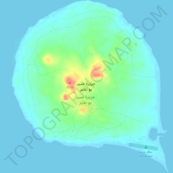
Name: Sir Bu Nair Island topographic map, elevation, terrain.
Location: Sir Bu Nair Island, Sharjah Emirate, United Arab Emirates (25.21051 54.19793 25.25278 54.24053)
Average elevation: 11 m
Minimum elevation: -1 m
Maximum elevation: 68 m
Other topographic maps
Click on a map to view its topography, its elevation and its terrain.
Khor Fakkan
United Arab Emirates > Sharjah Emirate
It is also a popular spot among domestic tourists due to its white sand beaches and coral reefs that attract many marine life enthusiasts. Khor Fakkan beach lies to the north of the center of the town. Khor Fakkan is located on the east coast of the UAE, between the Shumayliyah Mountains and the Arabian Sea,…
Average elevation: 132 m