
Somerset County topographic map
Interactive map
Click on the map to display elevation.
About this map
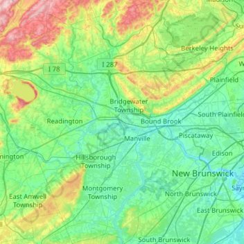
Name: Somerset County topographic map, elevation, terrain.
Location: Somerset County, New Jersey, United States (40.37439 -74.79788 40.75800 -74.40184)
Average elevation: 72 m
Minimum elevation: -1 m
Maximum elevation: 328 m
Other topographic maps
Click on a map to view its topography, its elevation and its terrain.
Monmouth County
In 1910, the Wright Brothers hosted an aviation show in Interlaken, where numerous records were broken, such as high altitudes, longest time airborne, the first night flight, and the first air mail delivery.
Average elevation: 19 m
Hunterdon County
Much of the county is hilly, with several hills rising to one thousand foot in elevation. The highest points are two areas in Lebanon Township, one on the Morris County line, both reaching approximately 1,060 feet (320 m) above sea level. The first is at Smith on the Morris County line and the second is north…
Average elevation: 120 m
Sussex County
The Delaware River forms the western and northwestern boundary of Sussex County. This region is known as the Upper Delaware Valley and historically as the Minisink or Minisink Valley. Elevations in the regions along the river range from 300 to 500 feet.
Average elevation: 250 m
Cape May County
Cape May County is 29 mi (47 km) long and 15 mi (24 km) at its widest. According to the 2010 Census, the county had a total area of 620.42 square miles (1,606.9 km2), including 251.42 square miles (651.2 km2) of land (40.5%) and 368.99 square miles (955.7 km2) of water (59.5%). The county is located about 150…
Average elevation: 1 m
Newark
United States > New Jersey > Essex County
According to the United States Census Bureau, the city had a total area of 25.89 square miles (67.1 km2), including 24.14 square miles (62.5 km2) of land and 1.74 square miles (4.5 km2) of water (6.72%). It has the third-smallest land area among the 100 most populous cities in the U.S., behind neighboring…
Average elevation: 22 m
Rutgers Ecological Preserve
United States > New Jersey > Middlesex County > Highland Park
Average elevation: 23 m
Bergen County
Bergen County's highest elevation is Bald Mountain near the New York state line in Mahwah, at 1,164 feet (355 m) above sea level. The county's lowest point is sea level, along the Hudson River, which in this region is a tidal estuary.
Average elevation: 66 m
Atlantic City
United States > New Jersey > Atlantic County
Because of its location in South Jersey, which hugs the Atlantic Ocean between marshlands and islands, Atlantic City was viewed by developers as prime real estate and a potential resort town. In 1853, the first commercial hotel, the Belloe House, which was built at the intersection of Massachusetts and…
Average elevation: 1 m
Twin Rivers
United States > New Jersey > Mercer County > East Windsor Township > Twin Rivers
Average elevation: 35 m
Iselin
United States > New Jersey > Middlesex County > Woodbridge Township > Iselin
Average elevation: 23 m
Madison
United States > New Jersey > Morris County
Madison's historic railroad station was funded by the community, which passed an ordinance authorizing $159,000 for railroad improvement bonds. The result, with the cooperation of the D.L. & W.R.R. in the planning, was completed in 1916. The tracks were elevated through the downtown so that no established…
Average elevation: 88 m
Trenton
United States > New Jersey > Mercer County
According to the Köppen climate classification, Trenton lies in the transition from a cooler humid continental climate (Dfa) and the warmer humid subtropical (Cfa), and precipitation fairly evenly distributed through the year. The Cfa climate is the result of adiabatic warming of the Appalachians, low…
Average elevation: 20 m
Kittatinny Mountain
United States > New Jersey > Sussex County
Kittatinny Mountain (Lenape: Kitahtëne) is a long ridge traversing primarily across Sussex County in northwestern New Jersey, running in a northeast-southwest axis, a continuation across the Delaware Water Gap of Pennsylvania's Blue Mountain (also known as Kittatinny Ridge). It is the first major ridge in the…
Average elevation: 266 m
Mount Tammany
United States > New Jersey > Warren County > Knowlton Township
Hiking on Mount Tammany consists of two trails. The red dot trail and the blue dot trail. The red dot trail is 1.2 miles and the blue dot trail is 1.8 miles. Combining the two for one of NJ's most popular hikes is a 3 mile loop. There is a 1201 feet elevation change going up and down the mountain. Generally,…
Average elevation: 267 m
Cranbury
United States > New Jersey > Middlesex County > Cranbury Township > Cranbury
Average elevation: 31 m
Leonardo
United States > New Jersey > Monmouth County > Middletown Township > Leonardo
Average elevation: 6 m
Rileyville
United States > New Jersey > Hunterdon County > East Amwell Township
Average elevation: 125 m
Whittingham
United States > New Jersey > Middlesex County > Monroe Township > Half Acre
Average elevation: 43 m
Ocean County
Much of the county is flat and coastal, with an extensive shoreline and many beaches along the Jersey Shore, including Barnegat Light, Beach Haven, Harvey Cedars, Lavallette, Mantoloking, Seaside Heights, Seaside Park, Ship Bottom, and Surf City. The highest point is one of three unnamed hills (one in Jackson…
Average elevation: 15 m
Woodbridge
United States > New Jersey > Middlesex County > Woodbridge Township
Average elevation: 16 m
Hudson County
The topography is marked by the New Jersey Palisades in the north with cliffs overlooking the Hudson to the east and less severe cuesta, or slope, to the west. They gradually level off to the southern peninsula, which is coastal and flat. The western region, around the Hackensack and Passaic is part of the New…
Average elevation: 12 m