
Make a donation
Gear up for your next adventure:
As an Amazon Associate, this site earns from qualifying purchases at no extra cost to you.
Barnard topographic map
Click on the map to display elevation.
Make a donation
Gear up for your next adventure:
As an Amazon Associate, this site earns from qualifying purchases at no extra cost to you.
About this map
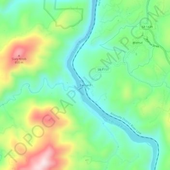
Name: Barnard topographic map, elevation, terrain.
Location: Barnard, Madison County, North Carolina, United States (35.81955 -82.77403 35.85955 -82.73403)
Average elevation: 601 m
Minimum elevation: 449 m
Maximum elevation: 899 m
Make a donation
Gear up for your next adventure:
As an Amazon Associate, this site earns from qualifying purchases at no extra cost to you.
Other topographic maps
Click on a map to view its topography, its elevation and its terrain.
Mars Hill
United States > North Carolina > Madison County
According to the United States Census Bureau, the town has a total area of 1.9 square miles (4.9 km2), all land. The town has an elevation of 2,330 feet (710 m), so the climate of the area is considerably cooler than might be expected of a town in a southern state.
Average elevation: 708 m
Mars Hill
United States > North Carolina > Madison County
The town has an elevation of 2,330 feet (710 m), so the climate of the area is considerably cooler than might be expected of a town in a southern state.
Average elevation: 708 m
Make a donation
Gear up for your next adventure:
As an Amazon Associate, this site earns from qualifying purchases at no extra cost to you.