Geolocate

Baseri topographic map

Interactive map

Click on the map to display elevation.

About this map

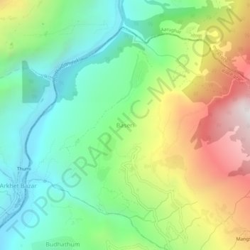
Name: Baseri topographic map, elevation, terrain.

Location: Baseri, Gangajamuna, Dhading, Bagmati Province, Nepal (28.08705 84.83503 28.12705 84.87503)

Average elevation: 1,091 m

Minimum elevation: 526 m

Maximum elevation: 2,082 m

Other topographic maps

Click on a map to view its topography, its elevation and its terrain.

Thade Tol

Nepal > Bagmati Province > Dhading > Dangsing

Average elevation: 1,276 m

Gumdi

Nepal > Bagmati Province > Dhading

Average elevation: 822 m

Chhapthok

Nepal > Bagmati Province > Dhading

Average elevation: 776 m

Semjong

Nepal > Bagmati Province > Dhading

Average elevation: 1,534 m

Salanghat

Nepal > Bagmati Province > Dhading > Malekhu

Average elevation: 617 m

Dhunibesi

Nepal > Bagmati Province > Dhading

Average elevation: 1,399 m

Malekhu

Nepal > Bagmati Province > Dhading

Average elevation: 681 m