Geolocate

Līgatne topographic map

Click on the map to display elevation.

About this map

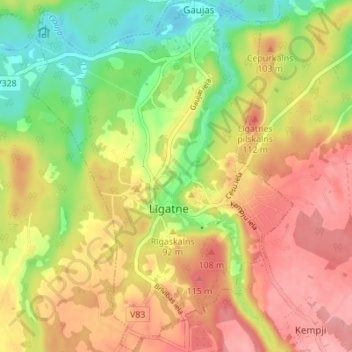
Name: Līgatne topographic map, elevation, terrain.

Location: Līgatne, Cēsu novads, Vidzeme, LV-4110, Latvia (57.21798 25.01319 57.25518 25.06418)

Average elevation: 71 m

Minimum elevation: 15 m

Maximum elevation: 118 m

Other topographic maps

Click on a map to view its topography, its elevation and its terrain.

Liepa

Latvia > Vidzeme > Cēsu novads

Average elevation: 78 m

Gear up for your next adventure:

🚶Walking Pedometers - Simple distance tracking for casual trail walkers
🧥Breathable Waterproof Jackets - Essential rain protection for the unpredictable British climate
Lightweight Solo Tents - Backpacking tents designed for wild camping in the UK highlands
👟Women's Trail Running Shoes - Agile footwear for fell running and technical trails
📕Outdoor Navigation Books - Learn traditional and modern navigation techniques

As an Amazon Associate, this site earns from qualifying purchases at no extra cost to you.