
Walferdange topographic map
Interactive map
Click on the map to display elevation.
About this map
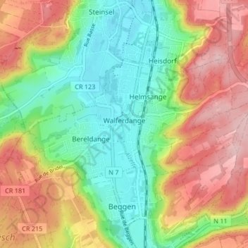
Name: Walferdange topographic map, elevation, terrain.
Location: Walferdange, Canton Luxembourg, Luxembourg (49.64627 6.09814 49.66940 6.16503)
Average elevation: 309 m
Minimum elevation: 224 m
Maximum elevation: 414 m
Other topographic maps
Click on a map to view its topography, its elevation and its terrain.
Luxembourg City: Old Quarters & Fortifications
Luxembourg > Canton Luxembourg > Luxembourg
Average elevation: 294 m