
Bugembe topographic map
Interactive map
Click on the map to display elevation.
About this map
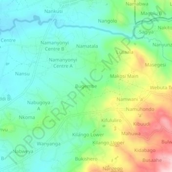
Name: Bugembe topographic map, elevation, terrain.
Location: Bugembe, Mbale City, Bugisa sub-region, Eastern Region, Uganda (1.08728 34.19380 1.12728 34.23380)
Average elevation: 1,209 m
Minimum elevation: 1,120 m
Maximum elevation: 1,406 m
Other topographic maps
Click on a map to view its topography, its elevation and its terrain.
Bishop Wasoke
Uganda > Bugisa sub-region > Mbale City
Bishop Wasoke, Mbale City, Bugisa sub-region, Eastern Region, Uganda
Average elevation: 1,129 m
Buwalasi
Uganda > Bugisa sub-region > Mbale City
Buwalasi, Mbale City, Bugisa sub-region, Eastern Region, Uganda
Average elevation: 1,282 m
Mukunja
Uganda > Bugisa sub-region > Mbale City
Mukunja, Mbale City, Bugisa sub-region, Eastern Region, Uganda
Average elevation: 1,159 m
Gangama
Uganda > Bugisa sub-region > Mbale City
Gangama, Mbale City, Bugisa sub-region, Eastern Region, Uganda
Average elevation: 1,134 m