
Hardeeville topographic map
Interactive map
Click on the map to display elevation.
About this map
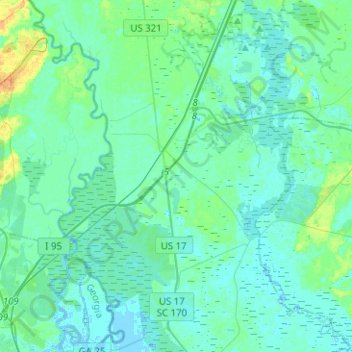
Name: Hardeeville topographic map, elevation, terrain.
Location: Hardeeville, Jasper County, South Carolina, United States (32.16501 -81.11998 32.37734 -80.92590)
Average elevation: 5 m
Minimum elevation: -4 m
Maximum elevation: 27 m
The city is located on the Atlantic coastal plain, with very few variations in elevation. The average elevation of the city is approximately 20 feet (6.1 m) above mean sea level. Most of Hardeeville is located within Jasper County, though a small portion of the city crosses into Beaufort County. Much of the city is bordered to the west by the Savannah National Wildlife Refuge, a large-scale nature preserve along the South Carolina and Georgia sides of the Savannah River.
Other topographic maps
Click on a map to view its topography, its elevation and its terrain.
Latitude Margaritaville
United States > South Carolina > Jasper County > Hardeeville
Latitude Margaritaville, Hardeeville, Jasper County, South Carolina, 29927, United States
Average elevation: 4 m