
Make a donation
Gear up for your next adventure:
As an Amazon Associate, this site earns from qualifying purchases at no extra cost to you.
Láchar topographic map
Click on the map to display elevation.
Make a donation
Gear up for your next adventure:
As an Amazon Associate, this site earns from qualifying purchases at no extra cost to you.
About this map
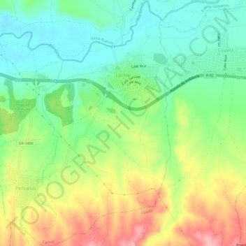
Name: Láchar topographic map, elevation, terrain.
Average elevation: 570 m
Minimum elevation: 515 m
Maximum elevation: 654 m
Make a donation
Gear up for your next adventure:
As an Amazon Associate, this site earns from qualifying purchases at no extra cost to you.
Other topographic maps
Click on a map to view its topography, its elevation and its terrain.
Dehesa del Generalife
España > Andalucía > Comarca de la Vega de Granada > Granada
Average elevation: 846 m
Canal de la Espartera
España > Andalucía > Comarca de la Vega de Granada > Dílar
Average elevation: 1,400 m
Make a donation
Gear up for your next adventure:
As an Amazon Associate, this site earns from qualifying purchases at no extra cost to you.
Mirador de San Miguel Alto
España > Andalucía > Comarca de la Vega de Granada > Granada
Average elevation: 802 m
Mirador de la Placeta de los Carvajales
España > Andalucía > Comarca de la Vega de Granada > Granada
Average elevation: 743 m
Pradollano
España > Andalucía > Comarca de la Vega de Granada
Pradollano (u oficialmente Sierra Nevada) es una localidad y pedanía española perteneciente al municipio de Monachil, en la provincia de Granada. Está situada en la parte suroriental de la comarca de la Vega de Granada. Cerca de esta localidad se encuentran los núcleos de Canales, Pinos Genil y Güéjar…
Average elevation: 2,281 m
Make a donation
Gear up for your next adventure:
As an Amazon Associate, this site earns from qualifying purchases at no extra cost to you.
Sierra de Huétor
España > Andalucía > Comarca de la Vega de Granada > Huétor de Santillán
Average elevation: 1,426 m
Make a donation
Gear up for your next adventure:
As an Amazon Associate, this site earns from qualifying purchases at no extra cost to you.
Mirador de San Nicolás
España > Andalucía > Comarca de la Vega de Granada > Granada
Average elevation: 760 m
Tozal del Cartujo
España > Andalucía > Comarca de la Vega de Granada > Dílar
Average elevation: 2,868 m
Fuente Grande
España > Andalucía > Comarca de la Vega de Granada > Fuente Grande
Average elevation: 1,193 m
Make a donation
Gear up for your next adventure:
As an Amazon Associate, this site earns from qualifying purchases at no extra cost to you.
Embalse de Canales
España > Andalucía > Comarca de la Vega de Granada > Güéjar Sierra
Average elevation: 1,161 m
Cerro del Zujeiro
España > Andalucía > Comarca de la Vega de Granada > Güéjar Sierra
Average elevation: 1,651 m
Alto de Calar
España > Andalucía > Comarca de la Vega de Granada > Güéjar Sierra
Average elevation: 1,507 m
Make a donation
Gear up for your next adventure:
As an Amazon Associate, this site earns from qualifying purchases at no extra cost to you.
Río Velillos
España > Andalucía > Comarca de la Vega de Granada > Pinos Puente > Búcor
Average elevation: 654 m
Parque del Cubillas
España > Andalucía > Comarca de la Vega de Granada > Albolote
Average elevation: 676 m
Make a donation
Gear up for your next adventure:
As an Amazon Associate, this site earns from qualifying purchases at no extra cost to you.
Casas Bajas
España > Andalucía > Comarca de la Vega de Granada > Vegas del Genil
Average elevation: 620 m
Prado Negro
España > Andalucía > Comarca de la Vega de Granada > Huétor de Santillán
Average elevation: 1,502 m
Lancha del Genil
España > Andalucía > Comarca de la Vega de Granada > Granada
Average elevation: 824 m
Make a donation
Gear up for your next adventure:
As an Amazon Associate, this site earns from qualifying purchases at no extra cost to you.
Fuente del Hervidero
España > Andalucía > Comarca de la Vega de Granada > Quéntar
Average elevation: 1,475 m
Belicena
España > Andalucía > Comarca de la Vega de Granada > Vegas del Genil
Average elevation: 612 m
Make a donation
Gear up for your next adventure:
As an Amazon Associate, this site earns from qualifying purchases at no extra cost to you.
Castañar de Güéjar Sierra
España > Andalucía > Comarca de la Vega de Granada > Güéjar Sierra
Average elevation: 1,237 m
Cumbres Verdes
España > Andalucía > Comarca de la Vega de Granada > La Zubia
Average elevation: 1,142 m
Cabeza del Caballo
España > Andalucía > Comarca de la Vega de Granada > Huétor de Santillán
Average elevation: 1,562 m
Make a donation
Gear up for your next adventure:
As an Amazon Associate, this site earns from qualifying purchases at no extra cost to you.
Gabia Grande
España > Andalucía > Comarca de la Vega de Granada > Las Gabias > Gabia Grande
Average elevation: 695 m
Make a donation
Gear up for your next adventure:
As an Amazon Associate, this site earns from qualifying purchases at no extra cost to you.
Cerro del Muerto
España > Andalucía > Comarca de la Vega de Granada > Huétor de Santillán
Average elevation: 1,462 m